
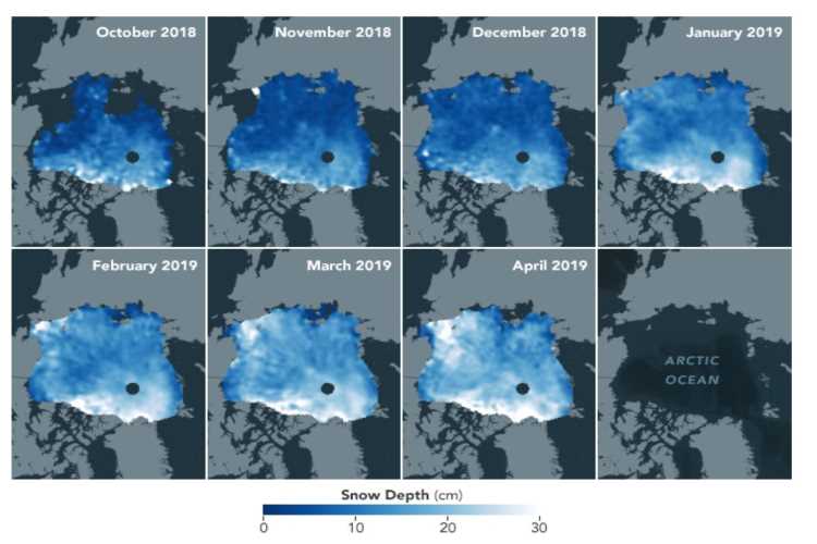
Scientists at NASA have created satellite-based maps of snow accumulation across the ice cover over the Arctic ocean that will help detect variations in the depth of snow throughout the year. The maps show the monthly average depth of snow across the Arctic region from October 2018 to April 2019.
“This is the first time ever that we can get snow depth across the entire Arctic Ocean’s sea ice cover,” said Ron Kwok, a scientist at NASA’s Jet Propulsion Laboratory. “What snow we do get is very important in terms of the climate and insulating sea ice,” a NASA release quoted him as saying.
They show snow cover beginning to accumulate in October, snow fall increasing in December and January and the cover reaching its maximum depth in April. With data covering more years of observations, these maps could help scientists measure the impact of climate change on precipitation and accumulation of snow.
READ: Fall in CO2 emissions not enough to stop climate change
Scientists compared measurements from two satellites — NASA’s Ice, Cloud and land Elevation Satellite-2 (ICESat-2) and the European Space Agency’s CryoSat-2 satellite. Using the data from the satellites, the scientists created a time-variable estimate of the snow depth, without using models.
Arctic sea ice cover has been declining over decades, affecting global ecosystems, weather, and climate. The maps track the changes in the insulating snow cover that determines how the ice grows and melts. The snow cover insulates ice from frigid polar air, slowing the growth of ice. In spring, and summer, snow cover slows the melting of ice.
READ: India’s storied middle class may be sliding into poverty
Scientists have been collecting snow depth data from ground and airborne surveys. The new maps will help them with routine, widespread data to detect variations throughout the year. Arctic sea ice is a very important determinant of climate. It keeps the earth cool by reflecting Sun’s energy back into the space.
The thickness of Arctic sea ice has fallen dramatically in the first 10 years of the current century. But the ice cover showed consistent thickness in the next 10 years. Measuring the thickness of ice has been difficult, but researchers are using data from ICESat-2 along with other data to get accurate measurements.

Sajna Nair is a former banker. Her areas of interest are environment, art and culture.