





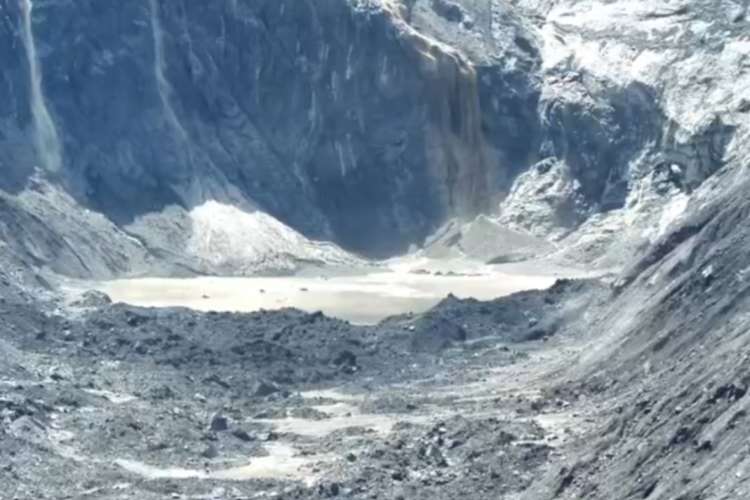
Gyirong glacier collapse: The collapse of ice and rock near Nepal’s Langtang Lirung glacier on August 26 sent a torrent of debris down the Trishuli valley and destroyed the Gyirong border crossing between Nepal and Tibet. By September 7, at least 1,380 people had died and more than 5,500 remained missing. Hydropower workers were among those trapped in tunnels beneath tonnes of mud and rubble. Nepal observed a national day of mourning as rescue teams continued searching the valley.
The toll makes this one of the gravest Himalayan disasters in recent memory. It also raises a question that governments across the region have avoided. Can roads, power projects and settlements continue to expand in mountain valleys without treating glacier collapse, landslides and debris flows as central planning risks?
READ | Retreat of Himalayan glaciers threatens South Asia’s future
A disaster larger than a glacial lake outburst
Initial descriptions called the Gyirong disaster a glacial lake outburst flood, or GLOF. The available evidence points to a different and more complicated chain of events.
Satellite images show that the lower part of a glacier broke away and fell hundreds of metres to the valley floor. Ice, rock and sediment then moved rapidly through the river system, generating floods farther downstream. Scientists have not yet established what initiated the collapse. A tremor detected at the time was first considered a possible earthquake, but the US Geological Survey concluded that it was seismic energy produced by the falling mass itself. Satellite evidence examined by Reuters confirms the broad sequence while leaving the precise trigger unresolved.
That distinction has consequences for disaster planning. Monitoring glacial lakes and moraine dams will not detect every high-altitude threat. Governments must also identify unstable glaciers, thawing permafrost, fractured rock faces and slopes carrying large accumulations of ice and sediment.
A preliminary reconstruction of the Gyirong event estimates that the mixed rock-and-ice mass descended about 3,400 metres and travelled nearly 22 kilometres before reaching Gyirong Port. The researchers caution that the source volume and mechanism of failure have yet to be determined. Such uncertainty is itself a reason to widen the hazard maps used for approving infrastructure.
Warming magnifies an unstable Himalayas
It would be premature to attribute a particular glacier collapse solely to climate change. Slope failures can result from several factors, including geology, temperature, water infiltration and changes in the support provided by ice or permafrost. Yet warming is altering the conditions under which these events occur.
The World Glacier Monitoring Service estimates that glaciers outside Greenland and Antarctica have lost more than 9,000 gigatonnes of ice since 1975. The Hindu Kush Himalayan region is undergoing rapid change. An ICIMOD assessment published in 2026 found that its glaciers lost about 12% of their area and 9% of estimated ice reserves between 1990 and 2020. The rate of ice loss has doubled since 2000.
As glaciers retreat, new lakes can form behind unstable natural barriers. Melting ice and permafrost can also reduce support for rock faces and expose loose sediment. Extreme rainfall adds water to already unstable slopes. A flood may therefore begin as a rockfall, glacier collapse, landslide or lake breach and gather destructive force as it moves downstream.
READ | Greenland’s glaciers are melting 100 times faster than estimates
This chain of hazards complicates forecasting. A warning system designed around river levels may detect the flood only after the mass has entered the channel. In steep Himalayan valleys, communities may then have minutes rather than hours to evacuate.
Infrastructure is increasing the exposure
The Gyirong crossing supported trade, tourism and pilgrimage, including travel towards Mount Kailash. The Trishuli valley also contains roads, settlements and hydropower projects. Their concentration along the river turned a high-altitude collapse into a national economic and humanitarian disaster.
Nepal has strong reasons to expand hydropower. It needs electricity, export earnings and alternatives to imported fossil fuels. India faces similar pressures in its Himalayan states. But the economics of a project change when planners underestimate the possibility of debris flows capable of destroying access roads, blocking tunnels or overwhelming structures.
Climate resilience cannot be added after a project has been approved. Environmental appraisal must cover the whole upstream catchment and the possible path of an ice-and-rock avalanche. Designers need to calculate debris loads, not merely expected water discharge. Powerhouses, worker accommodation, storage yards and emergency exits should be located outside identified flow channels wherever the terrain allows.
Road building and settlement expansion require the same scrutiny. Construction on floodplains, river terraces and old debris fans places people in routes used by previous disasters. Cutting slopes without adequate drainage can introduce an additional source of instability.
READ | Himalayan floods, climate crisis and the need for disaster diplomacy
Warning systems must lead to evacuation
Nepal is considering a new border warning network using seismic sensors, cameras and satellite communications. It has also sought more real-time information from China on glaciers and upstream water levels. Such cooperation is indispensable because Himalayan watersheds cross political borders while many of the most important monitoring sites lie in remote or restricted territory.
India’s National Disaster Management Authority issued guidelines on managing glacial lake outburst floods in 2020. The Gyirong disaster shows why these protocols should be extended to the full range of glacier, slope and debris-flow hazards. Priority valleys need continuous satellite surveillance supported by field instruments, river gauges and independent scientific review.
Equipment alone will not save lives. Alerts must reach district authorities and residents in language they understand. Evacuation routes should be marked and practised. Safe shelters must remain accessible when roads and mobile networks fail. Communities are more likely to obey an order when they know who issued it, where they should go and how long they may have to remain away from home.
Cross-border data sharing also needs fixed protocols. China, Nepal, India and Bhutan should agree on which readings must be exchanged, the agencies responsible and the communication channels to use when ordinary networks break down. Disaster information cannot depend on discretionary diplomatic exchanges after a flood has begun.
Governments will still have to accept residual risk. No monitoring system can predict every slope failure, and even the best warning may provide little lead time. That makes decisions about where to build as important as decisions about how to warn.
The policy choice is uncomfortable. Himalayan states need roads, electricity and jobs, but development that ignores the behaviour of a warming mountain system can destroy the assets it was meant to create. The lesson from Gyirong is that infrastructure policy must begin with the hazard map, not with the project proposal.