

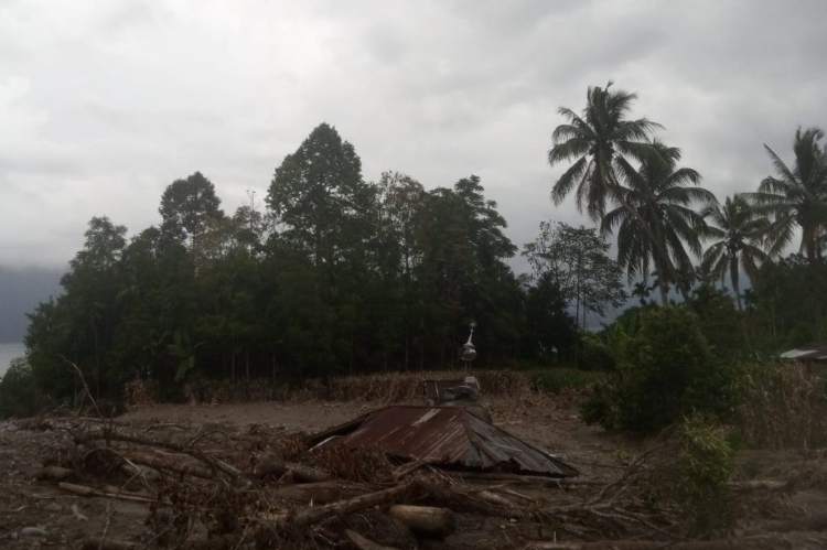
Severe floods and landslides in the provinces of North Sumatra, West Sumatra and Aceh in November which killed more than 1,000 people carried a bitter irony for Indonesia. Aceh, one of the hardest-hit provinces, had once been the epicentre of the 2004 Indian Ocean tsunami—a catastrophe that claimed more than 221,000 lives in Indonesia alone and became a turning point in the nation’s approach to disaster preparedness.
In the aftermath of that tragedy, Indonesia invested heavily in early warning systems, community education and international cooperation, with Aceh often cited as a symbol of resilience and recovery. The tsunami was supposed to be the defining lesson- that preparedness and mitigation could save lives.
READ I Climate diplomacy must account for domestic inequalities
Yet two decades later, the recent floods and landslides revealed how fragile those lessons remain in practice. Indonesia’s meteorological agency (BMKG) had issued clear warnings 10 days before the disaster, forecasting extreme rainfall and heightened risks of flooding and landslides. But the translation of those warnings into protective action faltered. Evacuation plans were either poorly communicated or underdeveloped, and many communities lacked the infrastructure and resources to respond. Roads collapsed, bridges were washed away, and villages were cut off, leaving residents stranded despite knowing the danger was coming.
The contrast between Aceh’s legacy of the 2004 tsunami and its vulnerability in 2025 underscores a troubling reality: preparedness is not a one-time achievement but a continuous process. While Indonesia built systems and institutions after the tsunami, enforcement of land-use regulations, investment in resilient infrastructure, and community-level readiness have not kept pace with environmental degradation and climate volatility. Deforestation and watershed destruction magnified the impact of the rains, turning the met office’s accurate forecasts into tragic inevitabilities.
The disaster also highlighted critical gaps in preparedness. While the National Disaster Management Agency (BNPB) declared emergency measures, the sheer scale of destruction overwhelmed local governments. Aid distribution was slow, and discrepancies in casualty reporting revealed weaknesses in data management.
READ I Climate change turns farms into migration corridors
2025 floods: Beyond a natural disaster
Environmental degradation compounded the crisis: deforestation and watershed destruction in Sumatra reduced the land’s natural capacity to absorb rainfall, turning heavy monsoon downpours into deadly floods and landslides. Experts stressed that climate change is intensifying such events, with Tropical Cyclone Senyar in the Malacca Strait amplifying the rainfall that triggered the disaster.
Politically, the fallout has been significant. Critics argue that Indonesia’s disaster management remains reactive rather than preventive, with insufficient investment in resilient infrastructure and weak enforcement against illegal logging. Governors in affected provinces declared a 14-day emergency response, but the devastation showed that preparedness measures had not kept pace with environmental realities.
For Indonesia, the November 2025 floods were more than a natural disaster; they were a stress test of its disaster preparedness system. The lessons are clear: without stronger coordination, environmental stewardship, and community-level readiness, even the most accurate forecasts will fail to prevent tragedy.
READ I Weakening AMOC threatens to hasten climate change
Indonesia is not inherently vulnerable to tropical cyclone threats, but we saw them more often that highlights the need for policymakers and disaster officials to adapt mitigation strategies.
The emergence of Cyclone Cempaka (2017), Cyclone Seroja (2021), and now Cyclone Senyar signals a shift in Indonesia’s extreme weather dynamics that policymakers must address.
Global climate change could influence the formation of such unusual cyclones, highlighting the need for policymakers and citizens to recognize its impact on Indonesia’s hydrometeorological risks. Geographically, the likelihood of such a disaster is relatively low in the waters surrounding Indonesia, which lies along the equator.
According to Indonesia’s meteorological agency, the degree of latitude of a place is one of the key factors that determine tropical cyclone formation. Tropical cyclones generally form beyond 5°N–5°S, or more than 500 kilometres from the equator. This is due to the small Coriolis force, an effect of Earth’s rotation causing winds and currents to curve rather than travel in a straight line, that forms cyclones in this region. The Coriolis force at the equator is zero. However, global climate change could trigger anomalous changes, urging increased awareness and action to mitigate future risks.
Cyclone Senyar brought extremely heavy rainfall, with data showing that on November 25-26, the average rainfall in the northeastern region of Aceh province exceeded 375 mm . This amount of rainfall is equivalent to what typically falls in a month in this region.
Furthermore, aggressive deforestation in the upper watershed areas of river basins also increased surface water flow, causing a massive flooding and landslides. According to data from the Ministry of Forestry, between 2019 and 2024, land cover in Aceh changed by 21,476 hectares from forest to non-forest, while in North Sumatra it changed by 9,424 hectares and in West Sumatra by 1,821 hectares.
Illegal logging activities also exacerbated the impact of the flooding , with large amounts of logs carried by the floods causing massive destruction. The steep slopes of upstream areas, composed of thick, bare soil/weathered rocks, contribute to landslides that can trigger natural river dams and transport material downstream. This is evidenced by the discovery of very thick flood sediment deposits at several flood-affected locations in Aceh, North Sumatra, and West Sumatra.
Cyclone Senyar caused a devastating loss of life and widespread damage, underscoring the importance of strengthening community resilience to foster a collective sense of responsibility and empower local efforts to better protect lives and property.
The national disaster management office reported that there are thousands dead, missing, and more than 5,000 injured. Also, more than a million people need to relocate due to this cyclone. The estimated cost for reconstruction and rehabilitation is around US$ 3.1 billion.
The failure to respond adequately to the met office’s warning shows that improving the dissemination of timely warnings and understanding multi-hazard threats are crucial for effective response. Affected populations must receive and comprehend critical information promptly. Reforestation and upstream forest protection are also vital, and a re-evaluation of spatial planning based on hazard maps and disaster mitigation must be undertaken to support sustainable development and resident safety.
Wahyu Wilopo is a Professor of Environmental Geology in the Department of Geological Engineering Universitas Gadjah Mada, Indonesia. He is a member of Global Alliance of Disaster Research Institutes (GADRI), Indonesia’s Geologist Association (IAGI), Indonesia Disaster Expert Association (IABI), etc. Originally published under Creative Commons by 360info
